The courses
There are four courses to choose from, 30, 50, 70 or 116 km (the ultra distance 450 km has its own event, see Storuman Gravel XL). All participants start at the same time regardless of the chosen course and until shortly after the first depot (at 20 km) all follow the same route. There, the longer courses turn left.
The maximum time is the same for all courses, 6½ hours, which means that the longer the distance you ride, the higher the average speed you need to keep. At 116 km you cannot be lazy, but on all the other courses there is plenty of time for both lunch and coffee breaks if you wish.
Maps, course profile and files for GPS navigation for each course is found further down the page.
Course characteristics
Storuman Gravel came about when we started thinking on our training rides that “it’s so nice to ride here that someone should really organize a cycling event right here”. The courses are thus central to why this event exists at all and we think they offer a high standard in terms of gravel cycling, and do that with a very unique character.
They are made specifically for the “new” genre of gravel cycling, that is long-distance cycling on gravel roads. The quality of the road surfaces varies, but there’s real road along the full route, so they are primarily for bikes without suspension. Of course, it is possible to use an MTB anyway, and many do, but you don’t have the advantage over a gravel bike.
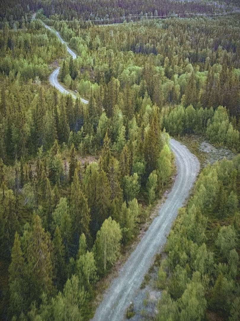
The courses go largely in a mountainous area and are hilly with an average of 100–130 meters elevation gain per 10 km (Stifa 10–13). You will thus notice that it’s hilly, but the mountains here have round soft shapes so it won’t be extreme, the steepest climbs will be 10-12% and the really steep parts are not too long. There are also some flat sections, so once the hills come, you will find quite long continuous sections both up and down, which few gravel events can offer. The course profiles give the elite a little something to work with, but without completely cracking down on the recreational riders. We think the courses offer a good balance — it’s tough, but still fun.
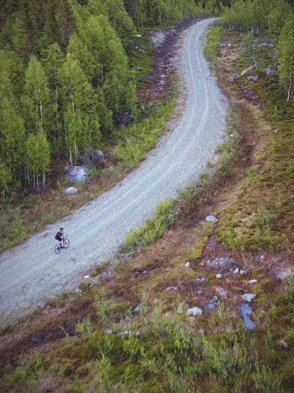
All the climbing you make, you get in return in nice flowing downhills, so no matter what your capacity is, you get plenty of fast and easy riding too at regular intervals. In some downhill sections you can get up to very high speed if you go for it (60+ km/h), but as long as you take it easy and use your brakes, the courses don’t contain any technical difficulties.
There aren’t many villages in the area so you do get an an experience of wilderness, and it’s very little traffic (but not zero, always be prepared for a car to appear). There are no stop signs, but we have a number of our own give way signs where you might have to stop. The roads themselves lack official road signs.
A slightly longer asphalt section (just over 7 km) appears 8 km into the courses, but the rest is gravel (except half a kilometer last bit towards the crossroads to Ensamheten). That 7 km asphalt section is longer than we wanted and the only place we feel we have been forced to compromise a bit to make the event work logistically. Seen to the whole, one can however see this section as a pleasant change where one can find a rhythm on a smooth fast surface before it's time to ride gravel in the mountains.
Expected time to finish
The purpose of having many different courses is that it should exist a reasonably tough challenge for everyone. Cyclists who haven’t done that many events before often choose an unnecessary short distance, however. One can certainly have a good reason to pick the 30 km course, but most can handle at least 50.
It can be better think in terms of time instead of distance, then it may seem more reasonable. Below is a table showing expected time to finish depending on how fast you ride:
| Beginner 15–20 km/h | Recreational 22–28 km/h | Elite 30–35 km/h | |
|---|---|---|---|
| 30 km | 1½ – 2 h | 1 – 1½ h | <1 h |
| 50 km | 2½ – 3½ h | 2 – 2½ h | 1½ – 2 h |
| 70 km | 3½ – 5 h | 2½ – 3½ h | 2 – 2½ h |
| 116 km | 6 – 10 h | 4½ – 6 h | 3½ – 4 h |
As you see in the table, if you can withstand a long time in the saddle, you can choose whichever course you want, with one exception: the 116 km course requires that you manage an average speed of almost 18 km/h to complete the maximum time of 6:30. If you are a beginner and want to cycle far, we therefore recommend that you choose 70 km instead.
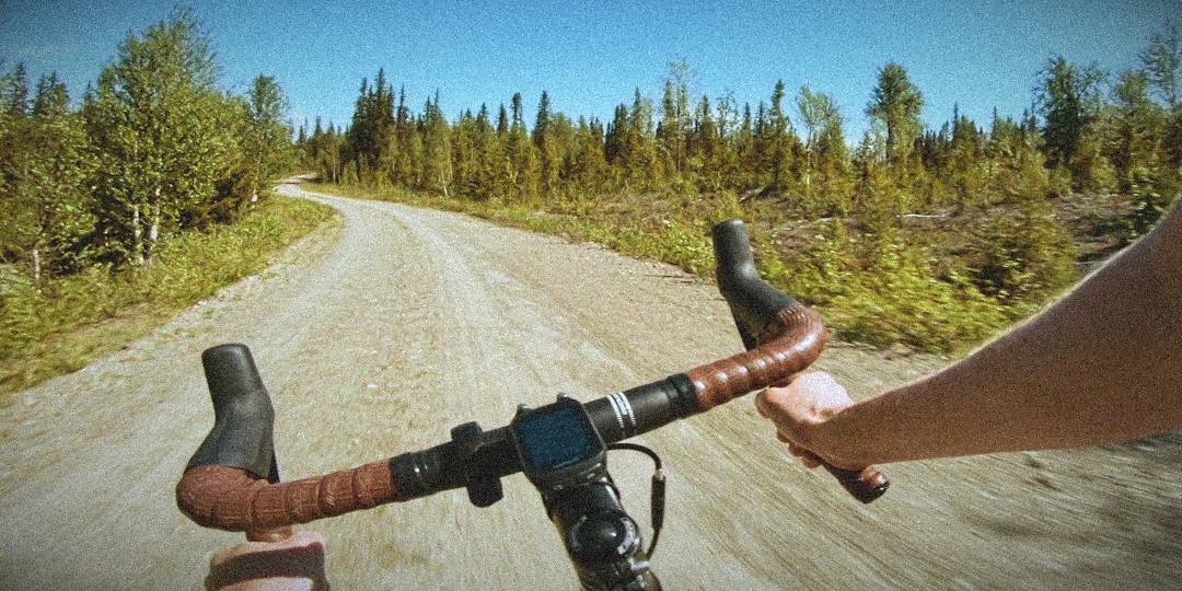
Video from the courses
Below is a video recorded in June 2020 where we ride one lap on the 70 km course. It shares distances with the other two courses so you also see what they look like. At the time for the video there were no signs or depots out of course. Since we recorded the video we have added the 116 km course, but in large parts it shares the same route as the 70 km.
We encourage you to watch the video so you are prepared for the various road surfaces and other challenges of the course.
GPS navigation
The courses are signposted, so it’s not necessary to have the course in a GPS-equipped bike computer, but if you happen to have one, it can be nice to have the course pre-loaded. Links to each course can be found in the information boxes further down the page.
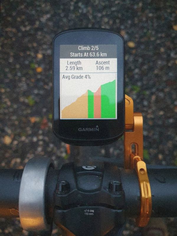
Some bike computers can show the track’s elevation profile, so you for example can see how long and steep an upcoming climb ahead is. For it to work well, the elevation data in the pre-loaded course needs to be reasonably accurate. Our “handmade” GPX/TCX files contain elevation data of good quality. The difference between the GPX and TCX file is that the latter contains notifications before turns.
If you want to use the elevation data stored in the file, you may need to use a special method to load the course. With Garmin devices, it doesn’t work (at the time of writing) to import via Garmin Connect, as it always replaces the file’s elevation with data from its own database with low data quality. You must instead upload the file directly (the method below applies to Garmin Edge):
- Start the GPS and delete old Storuman Gravel courses if you have it from previous years (we introduced good elevation data for the 2023 edition).
- Turn off the GPS and connect to a computer via a USB cable. The GPS should then appear as a USB memory stick.
- Copy the GPX file to the “Garmin/NewFiles” directory on the GPS.
- Disconnect the GPS from the USB cable and turn it on. The course with intact elevation data is now available in the navigation menu.
If you instead choose to load the course via Strava or other platform that we link to, the quality of the elevation data will likely be poor, but the shape of the course is exactly the same, of course.

The 30 km course is primarily intended for beginners or children (in the company of an adult). Due to the short length, there will be a fairly large proportion of asphalt (25%), but there will still be a bit of gravel cycling and adventure, you have to cross the mountain so it will be over 300 meters climbing in total (Stifa 10.7) and a solid downhill towards the end. However, we hope that you do not choose this course “unnecessarily”, as most people manage to level up to 50 km and that course shows much more of the fine gravel cycling that exists in the area.
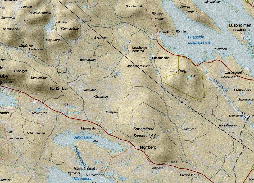
- 0 km: start in Ensamheten, the first section is 8 km gravel.
- 8.0 km: T-junction, turn right onto the road towards Långsjöby. Just under 8 km of fast asphalt awaits, past Hede, Norrberg and Hjalmarslund.
- 15.8 km: get off the asphalt to the right onto the Vallträsk gravel road towards Stortjärnliden.
- 18.5 km: first depot, in Stortjärnliden.
- 20.1 km: the 30k course continues forwards while 70 and 50k turn left in the junction.
- 22.8 km: the course’s highest point, from here it’s downhill.
- 29.0 km: turn right at the T-junction with paved Kungavägen, and right again towards Ensamheten after 630 meters.
- 30.4 km: back in Ensamheten and the finish line.
For GPS navigation: GPX, TCX, Strava, Garmin Connect, Plot a route.


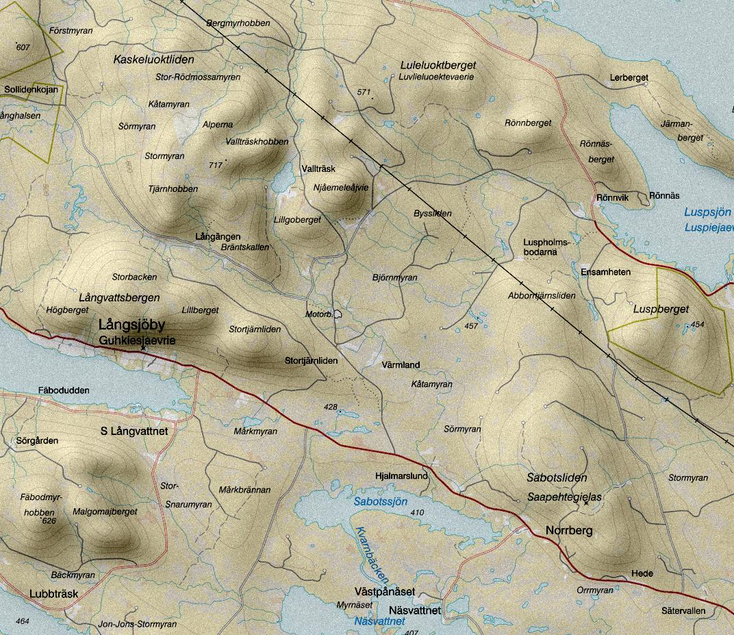

The 50k course provides a full gravel cycling experience and is recommended to anyone who wants to know what it’s all about, but at the same time keep the distance down. Large variation in surfaces and between flat and hilly. A total of about 640 meters to climb, Stifa 13.2.
- 0 km: start in Ensamheten, the first section is 8 km gravel.
- 8.0 km: T-junction, turn right onto the road towards Långsjöby. Just under 8 km of fast asphalt awaits, past Hede, Norrberg and Hjalmarslund.
- 15.8 km: get off the asphalt to the right onto the Vallträsk gravel road towards Stortjärnliden.
- 18.5 km: first depot, in Stortjärnliden.
- 20.1 km: the 30k course continues forwards while 50 and 70k turn left in the junction.
- 31.0 km: the highest point of the course beside the tarn Nyängestjärnen. Downhill from here to a T-junction with the Rullmyr gravel road, turn right there. This downhill section has some sharp corners with loose coarse gravel, be careful and brake in time!
- 34.6 km: second depot. The 70k course turns left in the junction, while the 50k continues ahead 130 meters to the depot and turns right onto the old Vallträsk gravel road up towards Vallträsk.
- 37.8 km: the cabin in Vallträsk, a fast downhill starts soon. The road surface in this downhill section is in some places very poor, be careful!
- 40.0 km: warning: downhill into four-way intersection. turn left onto the new Vallträsk gravel road.
- 47.0 km: turn right at the T-junction with paved Kungavägen, and right again towards Ensamheten after 630 meters.
- 48.6 km: back in Ensamheten and the finish line.
For GPS navigation: GPX, TCX, Strava, Garmin Connect, Plot a route.


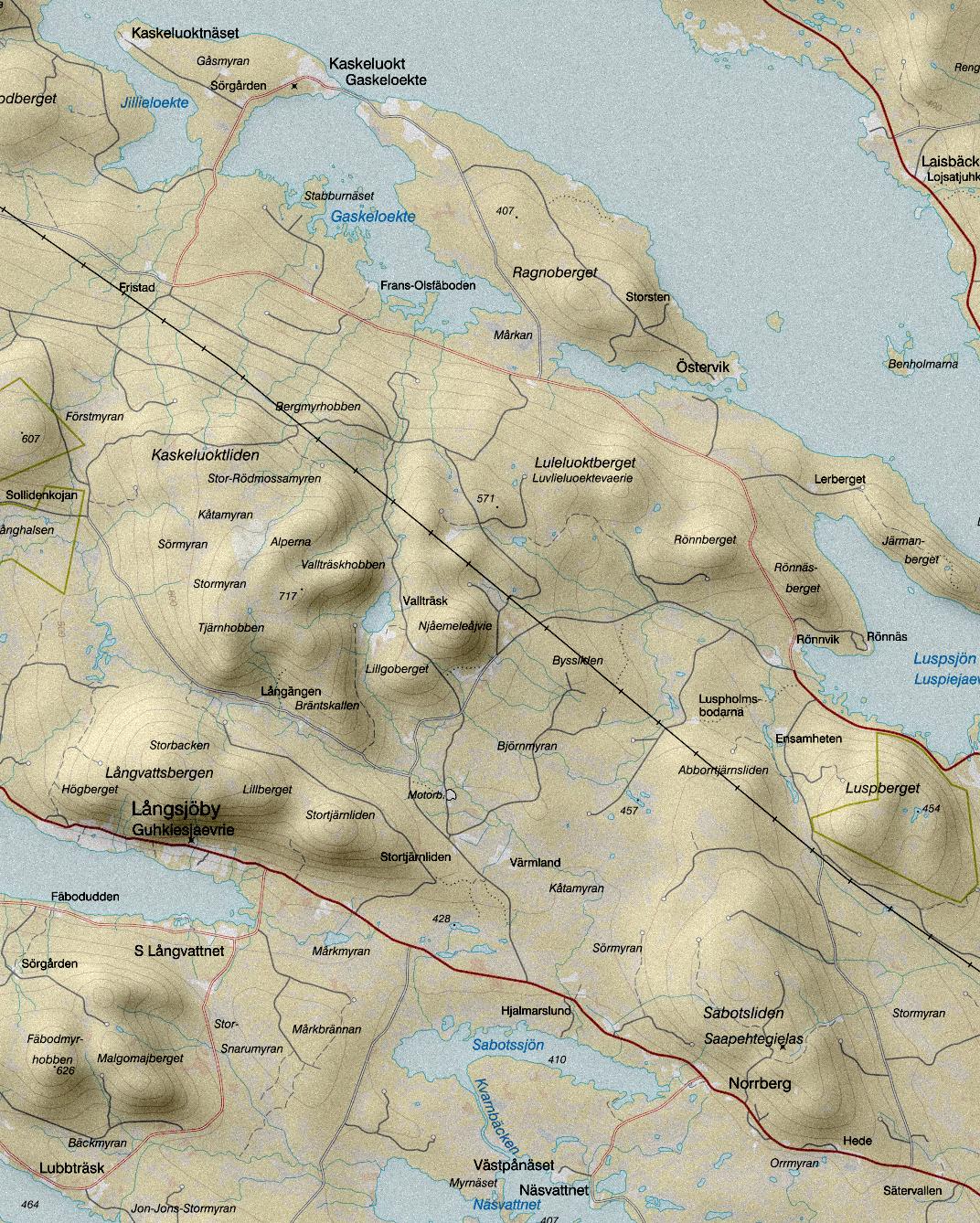

The 70 km course takes 2½ - 3½ hours for most riders and is recommended for those who want a somewhat tougher challenge but are not prepared for the longest distance. It has it all: fast flat sections, properly hilly sections and varied surfaces — just over 10% asphalt, 30% smooth and fine gravel roads and 60% with slightly coarser and more uneven surfaces. The total climbing is about 890 meters, Stifa 12.9. The extra 20 kilometers on top of the 50k course consists of a nice mellow road all the way down from the mountain, then a relatively fast flat loop past the village of Kaskeluokt, over the suspension bridge, and ends with a tough climb back up the mountain.
- 0 km: start in Ensamheten, the first section is 8 km gravel.
- 8.0 km: T-junction, turn right onto the road towards Långsjöby. Just under 8 km of fast asphalt awaits, past Hede, Norrberg and Hjalmarslund.
- 15.8 km: get off the asphalt to the right onto the Vallträsk gravel road towards Stortjärnliden.
- 18.5 km: first depot, in Stortjärnliden.
- 20.1 km: the 30k course continues forwards while 70 and 50k turn left in the junction.
- 31.0 km: the highest point of the course beside the tarn Nyängestjärnen. Downhill from here to a T-junction with the Rullmyr gravel road, turn right there. This downhill section has some sharp corners with loose coarse gravel, be careful and use the brakes!
- 34.6 km: second depot. The 50k course continues ahead, while the 70k turns left onto the old Vallträsk gravel road.
- 39.6 km: downhill into four-way intersection with Kungavägen. Ride straight over towards Kaskeluokt.
- 45.0 km: the suspension bridge in Kaskeluokt.
- 51.6 km: T-junction towards Kungavägen, turn right and then the first left (after 500 meters) onto the Rullmyr gravel road. The toughest hill of the course awaits.
- 55.6 km: back in the depot and shared course with the 50k. Turn left onto the old Vallträsk gravel road.
- 58.7 km: the cabin in Vallträsk, a fast downhill starts soon. The road surface in this downhill section is in some places very poor, be careful!
- 60.9 km: downhill into four-way intersection. Turn left onto the new Vallträsk gravel road.
- 67.9 km: turn right at the T-junction with paved Kungavägen, and right again towards Ensamheten after 630 meters.
- 69.4 km: back in Ensamheten and the finish line.
For GPS navigation: GPX, TCX, Strava, Garmin Connect, Plot a route.


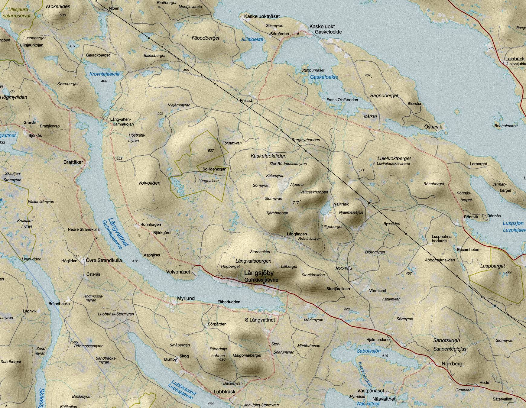

116 km means a long time in the saddle even if you are fast, so the course is only recommended for cyclists who are used to being several hours in the saddle. If you are not, you can get some pains both here and there before you reach the finish line. In addition to the 70k course, you first get a loop to the northwest towards Ullisjaur and Vackerliden. It goes down and up the mountain, so both a nice downhill stretch and a climb with a slightly longer flatter section in the middle. After just over 70 km at Fristad, the course takes you on a small detour to Kaskeluokt by rounding Fäbodberget on somewhat rough roads. The rest follows the same route as the 70k course. In total, there will be just over 1300 meters of climbing (Stifa 11.4).
The lowest average speed to finish with the maximum time of 6½ hours is just under 18 km/h, which means that there is not time for any long breaks.
- 0 km: start in Ensamheten. Uphill along the foot of the mountain Luspberget, transitions at the powerline into easy riding along Stormyrvägen past Sabotsliden.
- 8.0 km: T-junction with right turn onto the road towards Långsjöby. Just under 8 km of fast asphalt awaits, past Hede, Norrberg and Hjalmarslund.
- 15.8 km: get off the asphalt to the right onto the Vallträsk gravel road towards Stortjärnliden and the mountains.
- 18.5 km: first depot, in Stortjärnliden. A bit early, to serve the short courses, but keep in mind the next depot is not until 30 more kilometers.
- 20.1 km: the 30k course continues forwards while the others turn left onto Långängsvägen. Now it becomes a bit more hilly.
- 27.7 km: the 116k course turns left and sweeps down between Volvoliden and Rönnberget while 50 and 70k continues forward on what becomes Nyängsvägen.
- 34.7 km: downhill into T-junction. Turn right onto road 1100 which is unpaved here. It will be relatively flat and fast 10k towards Ullisjaur.
- 43.9 km: right turn onto Vackerlidvägen which starts at Ullisjaur lakeside and rounds Luspeberget. Seldom driven road with a string of grass.
- 48.8 km: depot directly after the bridge over Långvattsbäcken which flows again after resting in Grotjaur.
- 51.6 km: T-junction, turn right onto Kungavägen, and after three kilometers turn right onto Baktisvägen and climb back up towards Rönnberget.
- 63.1 km: left on to Nyängsvägen and back to the shared course.
- 65.8 km: the highest point of the course beside the tarn Nyängestjärnen. Downhill from here to a T-junction with the Rullmyr gravel road, turn right there. This downhill section has some sharp corners with loose coarse gravel, be careful and use the brakes!
- 69.3 km: left turn at the end of a fast downhill section. If you want to refuel there’s a depot a short detour straight ahead (see separate map on the info page).
- 74.2 km: downhill into four-way intersection with Kungavägen. Ride straight over towards Kaskeluokt.
- 78.1 km: turn right and begin a loop around Fäbodberget.
- 88.8 km: back to shared route with the 70k course. T-junction with left turn towards Kaskeluokt.
- 92.1 km: the suspension bridge in Kaskeluokt.
- 98.6 km: T-junction towards Kungavägen, turn right and then the first left (after 500 meters) onto the Rullmyr gravel road. The toughest hill of the course awaits.
- 102.6 km: back in the depot and shared course with the 50k. Turn left onto the old Vallträsk gravel road.
- 105.7 km: the cabin in Vallträsk, a fast downhill starts soon. The road surface in this downhill section is in some places very poor, be careful!
- 108.0 km: downhill into four-way intersection. Turn left onto the new Vallträsk gravel road.
- 115.0 km: turn right at the T-junction with paved Kungavägen, and right again towards Ensamheten after 630 meters.
- 116.4 km: back in Ensamheten and the finish line.
For GPS navigation: GPX, TCX, Strava, Garmin Connect, Plot a route.

